LAZAROW WORLD HIKE-ABOUT

Nepal: Evening below Annapurna.

'LAZAROW WORLD HIKE-ABOUT: WHAT IN THE WORLD IS HIKE-ABOUT?'

Hike-about is an adventure that commenced June 2010. After storing our household movables, ridding ourselves of a house but retaining our 'home' together, we set off with the purpose of hiking in different parts of the world, not forgetting the home country, the USA.

Our primary focus is hiking to mountain peaks but any challenging hike will do just fine. Extended stays enable us to enjoy and experience living in various places amongst differing cultures. Hike-about has evolved into a way of life. It's also a process of discovery, both the world and ourselves.

We work and live 'on the road' but return to the city in which our grandchildren reside, every couple of months. This provides us the wonderful opportunity to be with them as well as a child or two, even three and of course, friends.

By the end of 2023, the blog contained over 1,560 hikes (less than that actually undertaken), each a set of pictures with stories and anecdotes from the trails. An index to the right allows the viewer to identify earlier experiences.

Finally, we are often asked about the journey's end.
O
ur reply, as accurate as we can state, is: "When we are either forced to cease through health issues or the enjoyment level no longer reaches our aspirations, we will hang up the boots."

"A Life Experience As No Other: Dare to Seize the Day Together", published by Fulton Books, depicts our life on the road and mountains until the beginning of 2017. It has developed 'exponentially' since then.

Jenni and Jeffrey Lazarow

Whereas we continue to update the blog regularly, we circulate email notifications infrequently.

Thursday, December 31, 2015

24.37 Mount Wasson via Kings Canyon. 24.38 Soldiers' Trail to Bear Canyon, Tucson, Arizona. 23.39 Peart Rd. Trail, Casa Grande, AZ


The former were two testing hikes, probably about nine miles each with well over 2,000 feet of elevation gain;
the third in the city of Casa Grande, quite long but with insufficient height gain to make it worth recommending.
The hikes in Tucson, mostly amongst cacti, attractive mountains and great views, are enough to bring us back for more.

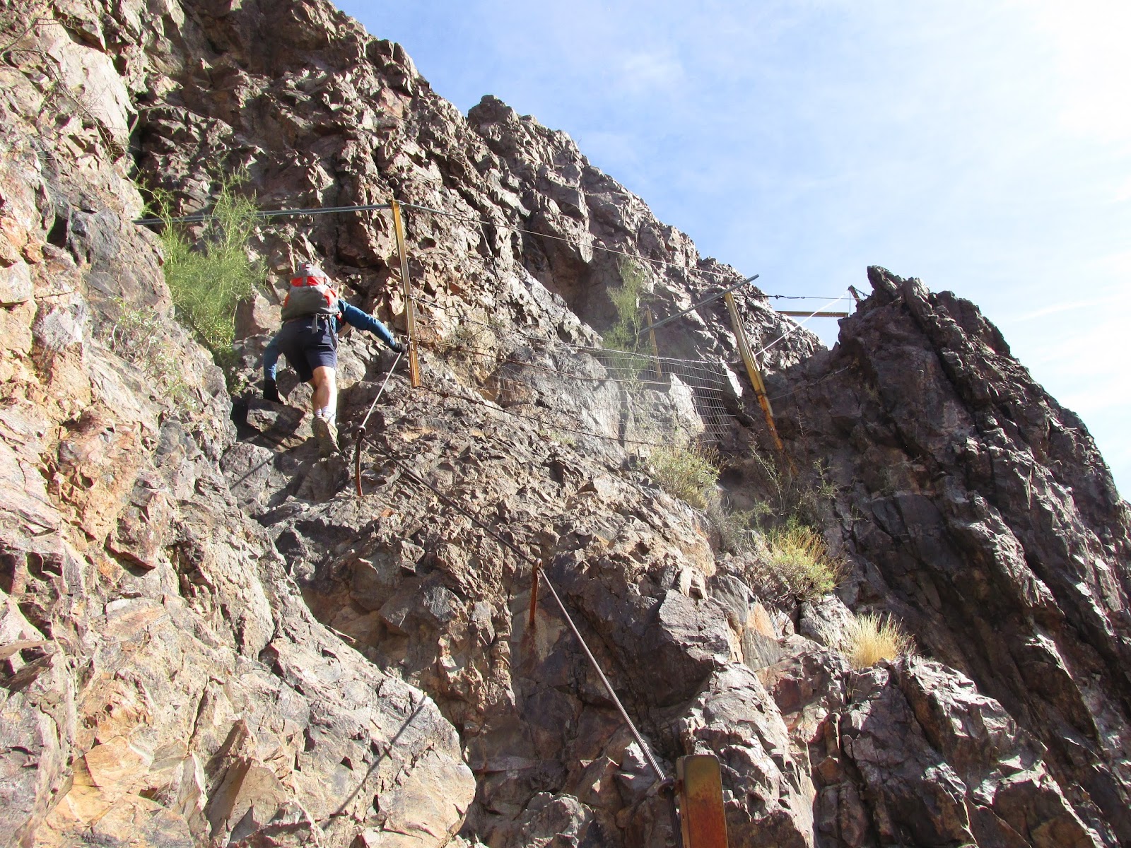
The soldiers' trail leads to a former prison camp which is reached directly from a road on the other side of the mountain,
opposite from our commencement point. However, we diverted to Bear Canyon which is an over-powering sight further along.

The hike up to Wasson Peak is on the tough side. It made for a little more of a challenge when we reached the very steep
section. At that juncture, there was a fellow on our heels. One of us did not want to be passed so it became a 'race'
to the top. The problem was that the other guy was a tough competitor. Oh well! No wonder Jenni shakes her head so often.

This concludes Hike-about 24, an incredible experience. At the end we include a few meaningful pictures from the period.


'I'm leaving on a jet plane, don't know when..."


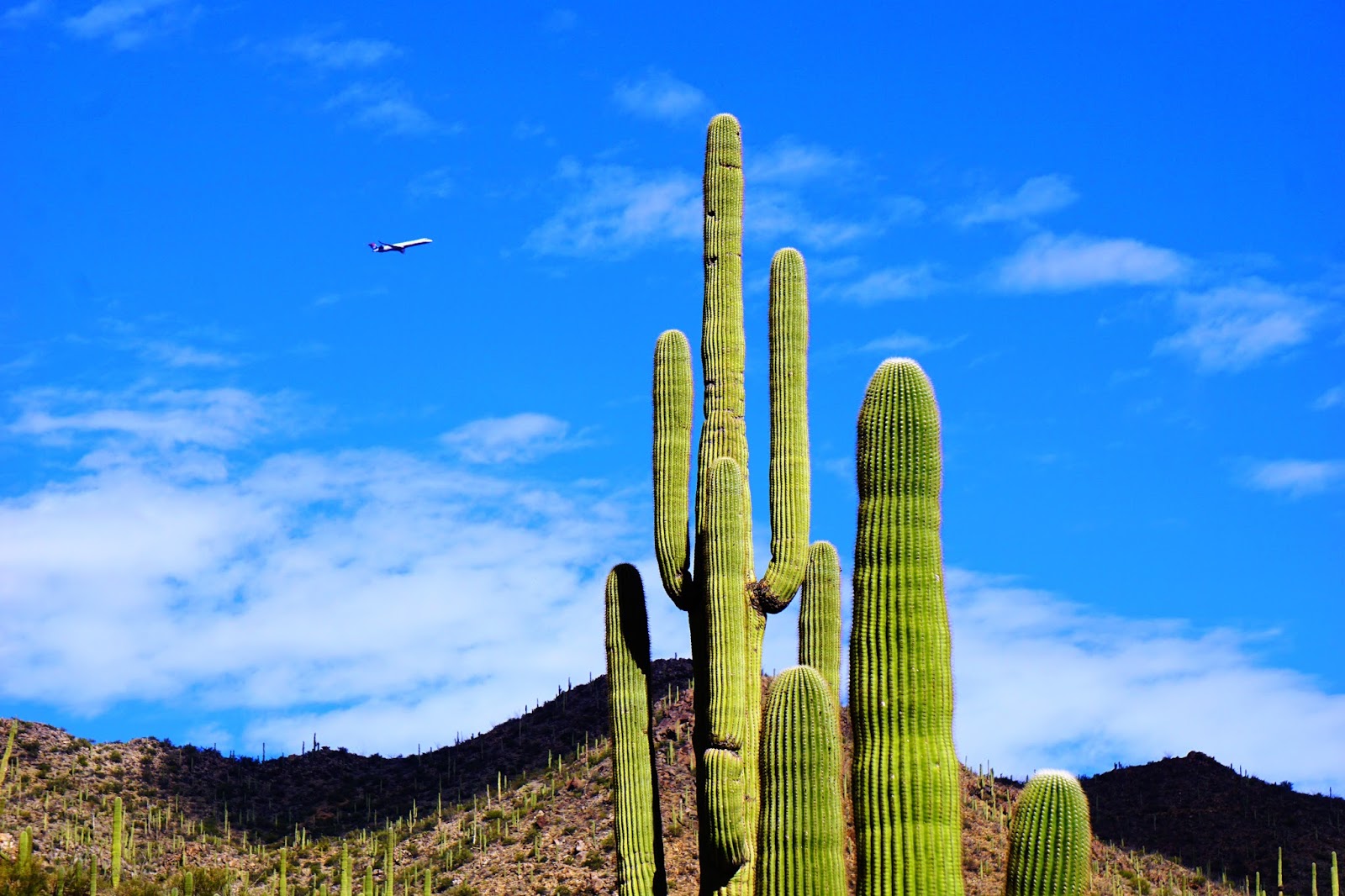
Apparently, the approach to a saguaro is from above.


We've heard of prickly but this is a contagion.


'Lucky' it does not rain too often.


Climbing out of the canyon on Soldiers' Trail.


Mountains and farmland in Casa Grande, Arizona.


A shady view from Mount Wasson Peak.


Peek-a-boo Ellie and Benny.


Jen stands above Bear Canyon, the end of our trail, with an amazing backdrop.


'The Long and Winding Road'...Hmm! Doesn't work too well in this situation. (Taken from early
on along the Soldiers' Trail.


A few meaningful pictures from Hike-about 24 as we conclude and close the chapter:


Blacketts Ridge, Tucson...Jenni celebrates her birthday.


Nightfall in the desert, White Sands National Monument, a sea of sand.


Turnaround at Ice Lakes Basin, tracking an incoming storm, Silverton, Colorado.


Valley of Fire State Park, Nevada.


Heading for Wheeler Peak, New Mexico.


Reaching summit of Angels Landing, Zion, Utah.


Ice Lakes Basin, Colorado.


Wheeler Summit, New Mexico.


The desert runner, White Sands, New Mexico.


Cheers,


Jenni and Jeffrey

Thursday, December 24, 2015

24.34 Baylor West, Los Cruces, NM 24.35 Madera Park, Super Trail Loop. 24.36 Agua Caliente Peak, Tucson.


Some of the places visited have provided wonderful hiking opportunities but not always unique or different views.
Because we have avoided early morning cold weather recently, often the light has not been ideal for photography.
We decided to visit Los Cruces in New Mexico on our way to Tucson from Texas. We admit our ignorance in
not knowing much about the city. It turns out that it's the second largest in the state by size of population.
New Mexico does not have many residents, perhaps a lot have returned to Old Mexico. This city has less than
a hundred thousand people. Albuquerque, the largest city in the state, is the only one with residents in excess
of that latter number.


I was delighted to come across this sign at the beginning of the hike. I often have to warn the editor about fooling around with rattlesnakes. But does she listen? Of course not. Hopefully, the warning will help in the future. I was getting very weary of watching her pat, pet and tickle the rattlers on the trails. Why she has a fascination for these critters is beyond me. I hope she applies the approach suggested to encounters with grizzlies, too. However, who can tell what goes on in her mind.


Into the bush they rode...wrong poem. Looking towards our peak after forty minutes.


On the outskirts of Los Cruces, we admire the small mountains that we can view unhindered from
their bases to peaks.


Nice views as we acquire height.


The formations were quite different.


A serene scene viewed from our saddle.


Madera Monument

A fairly tough trail of 9 miles and on narrow edges at times.


A view from the ridge in Madera National Monument, south of Tucson.


Agua Caliente Peak Trail


We climbed 2,800 feet over 9 miles on an almost deserted trail one early Sunday morning. Of the few people we
came across, two were hunters returning from a fruitless hunt. We chatted a while and were relieved to see
that they were unsuccessful on the day—a deer or two live for another day.


While standing on the peak of Agua Caliente hike, we viewed the Santa Rita range. The photo
above is part of that range on which we hiked two days later.


A view into the valley from below the peak.


Tucson, the city of cacti


Cheers,


Jenni and Jeffrey

Sunday, December 20, 2015

A different view from Mount Woodson, Poway, California.


While we still have a number of blogs from Hike-about 24 unpublished, we took a Sunday hike to the
peak of Mount Woodson. It's a firm favorite and quite a climb for this 8-mile round trip city hike in
Poway, part of San Diego County.
We are officially resting but continue to hike a little and visit the gym each morning to try and stay fit.
The cross-training seems to be a good idea and certainly makes us feel strong and upbeat for part of the day before
collapsing. We think we can still feel the effects of the forty hikes we undertook in the six western states visited
recently. We've posted a few pictures below to give friends an idea of what might be expected should they take
up our offer for a hike on December 25th. See invitation after the pictures.


A late bloomer or is it very early spring?


A strong mist sets the early morning tone.


Variety observed from the peak including a pond.


Sun struggles to break through the clouds.


To get it to sit still is almost impossible. The editor can be intimidating.


The sun finally breaks through and strikes the boulders.


A view from the top


A closer look at the 'golden pond'.


Cheers,


Jenni and Jeffrey


‘Hear Ye All’.

Jenni invites you to join us for our P.I. (politically incorrect) bi-annual hike up Iron Mountain (and down, hopefully) on December 25th. We will meet in the car park at 5:55am. While it might seem early, arguably it’s the most beautiful part of the day. Should there be snow, blizzards or torrential rain then the hike will be moved back an hour by which time San Diego weather would typically have cleared.

Excuses: Why would we be expecting these? Those residing outside the United States are excused. Anyone east of the Mississippi or who can spell the name of the river on a first attempt is also excused—intellectuals get a free-pass. There are also prizes for the expected first eighty best excuses.

Religious Holiday: This is an acceptable reason to miss the experience but obviously does not apply to Muslims and Jews. People are welcome to pray at the peak or anywhere in-between. We offer no guarantee that prayers will be answered.
Rules and regulations: We are playing this by ‘the book’. Federal rules are applicable as well as state, county, city and school district ordinances. Please contact us for a full set of legal tomes.

All are invited. There will be no discrimination against any participant based on race, religion, national origin, ill-fitting clothes, sexual orientation, left-handers, age or gender. However, Congressional members are not invited nor are presidents, junior varsity types or otherwise or those taking advantage of young women in the White House.

Toilets: There are toilets at the trailhead but none available for trans-genders. Fortunately, there are wide-open spaces available.
Special groups. To the many male hikers we have met in the great State of Utah, unfortunately, there are a few restrictions. You may bring only one wife with you but up to three girlfriends.

Decorum: In case there are insufficient rules, we wish to add another. Men are encouraged to act ‘macho’ by racing women up the mountain. However, whenever passing someone from the delightful, female gender you shall raise your hat.
Light: The sun rises soon after we commence (Thus far it has never failed.). Nevertheless, bring along a flashlight; South Africans should carry a torch for the initial stage.

Pets and food: Women should feel free to bring along a dog, husband or other pet. (Please, not more than one of each.) Breakfast at the peak is always a delight. However, you have to carry your own food as the restaurant at the summit is closed for the holidays. Also bring water. Funnily enough, tap (faucet) water is quite acceptable.

Should you have any other questions, don’t hesitate to contact Jenni. For questions on editing, avoid contacting her—she can break your spirit.

We look forward to seeing both of you on Friday. Please note we depart at 6am sharp. (We are not on ‘Jewish time’).


Cheers,

Jenni.

P.S. We’d like to take this opportunity of wishing all our Christian friends a merry and meaningful Christmas and a year filled with good health and cheer.

Thursday, December 17, 2015

24.32 McKittrick Canyon Trail via Permian Ridge, Guadalupe National Park, Texas. 24.33 City of Rocks, New Mexico.


Guadalupe National Park in Texas is impressive because it is set in a mountainous region, one of few in the state.
More than that though, it has a tranquility, a rugged neatness, if you will, sights into the distance including salt
pans, surrounding mountains and special views of smaller peaks from the high spots. Earlier in the week, we climbed
to the peak of the highpoint in Texas, also probably the windiest, too and were rewarded immensely. This hike was a little
over 2,000 feet of elevation gain along winding paths on outside edges with a return distance of 8.5 miles. We had the
trail to ourselves although we had views of fellow hikers moving along the wash below.


A view of late-autumn color as we make our way up.


The path towards the top or bottom.


One of many reasons we find the park so attractive


A view into the canyon and its walls.


A view from above which gives a fair reflection of the scrub and the 'well-scrubbed'.


The editor reaches the peak and leans a little. Makes one wonder.


City of Rocks is a small state park in New Mexico with fascinating, large boulders and rocks that formed
from the hot ashes following a volcano eruption a few years before our time...maybe, everyone else's, too.


Editor searching for a breakfast spot.


"Is this the way to San Jose?" 'No, Dummy, it's obviously a bus station.'


Yep! Showing off again or actually, having a good time.


Cheers,


Jenni and Jeffrey

Sunday, December 6, 2015

24.31 Picacho Mountain, Arizona, an adrenaline producing climb.


A fellow we met on Mount Wasson, Mike, suggested we try out the hike to the summit of Picacho Mountain.
He described it briefly and it seemed to be much like Angels Landing in Zion. We found it had some common features
with the Angel but they are each unique—great experiences but different. The editor was apprehensive when she heard
that the length is 2.1 miles one way but the cumulative elevation gain is 1,800 feet with cables in quite a few places.
She enjoyed some great whining although assured me it was all in good spirit. I’m still trying to figure out that
classification of whining. She also told me that throughout the hike she decided ‘never again’. The following day,
she also mentioned that she looks forward to repeating the climb. I’m wondering which of the dual personalities
to believe. Nevertheless, she was grand all the way....as always.


After reading the sign, the editor became a little tense.


A view of Picacho Peak from Casa Grande Mountain. It illustrates the two peaks nicely. There's no
McDonald's at the top, nevertheless, we enjoyed breakfast on the high point.


Bird's-eye view of the desert surface covered in saguaros as seen from Picacho Peak.


There goes 'tiger' as she climbs some extremely steep sections.


To Life! Being alive.


When we reached that point, we went down again only to climb steeply thereafter.


Going down on the way up.


The mountain lies between Tucson and Phoenix, closer to the former, in the State Park of the same name.
It has a distinctive look with three peaks and two saddles. The puzzle was guessing which of the three peaks
would be the final destination. In the end, we were wrong. The trail commences gently for a short while and then
rises quickly to a saddle. It then heads down sharply arriving close to the desert surface on the other side
of the mountain. Effectively, a person goes over the saddle, up and down. It then begins a sharp ascent to the top
with extremely steep parts, often with cables along the way to provide extra support. There are many places where
sharp-edged rocks provide a good grip for the boots making it possible to avoid using the cables. However, we imagine
many people hold on to those cables—some extremely tightly.


Going up again.


Smaller peak below us.


Standing near a vertical wall to capture the scene.


Getting closer.


Finally: Picacho Peak.


A view from the summit.


Once at the summit, there is another climb to a peak which has a small but flat top with ideal rocks to seat
oneself and eat breakfast—something we did. The view of the desert surface, covered in saguaros, is a delight
to observe. The mountains towards Tucson softened by the haze and mid-morning light, approximately forty miles south,
created visuals that mesmerized us. In fact, the effect on me was so great that I exclaimed, “Life!” We don’t know
whether that’s easily explainable but it made sense to us.

Finally, during our stay in Tucson it became easy to differentiate visitors from the locals. It seems the 'Tucsonians',
if that’s the correct word, love their college so much that most wear a cap, sweater or badge identifying with
the institution. Go Bearcats!


Along one of the cliff walls.


Although rated difficult, it's a great hike with thrills and hopefully 'no spills'; it is not
difficult, in our opinion. Then again, terms are relative and also depend on many other circumstances.


Cheers,

Jenni and Jeffrey