LAZAROW WORLD HIKE-ABOUT

Gibraltar, Great Britain- Rocking in Spain...hmm!

'LAZAROW WORLD HIKE-ABOUT: WHAT IN THE WORLD IS HIKE-ABOUT?'

Hike-about is an adventure that commenced June 2010. After storing our household movables, ridding ourselves of a house but retaining our 'home' together, we set off with the purpose of hiking in different parts of the world, not forgetting the home country, the USA.

Our primary focus is hiking to mountain peaks but any challenging hike will do just fine. Extended stays enable us to enjoy and experience living in various places amongst differing cultures. Hike-about has evolved into a way of life. It's also a process of discovery, both the world and ourselves.

We work and live 'on the road' but return to the city in which our grandchildren reside, every couple of months. This provides us the wonderful opportunity to be with them as well as a child or two, even three and of course, friends.

By the end of 2023, the blog contained over 1,560 hikes (less than that actually undertaken), each a set of pictures with stories and anecdotes from the trails. An index to the right allows the viewer to identify earlier experiences.

Finally, we are often asked about the journey's end.
O
ur reply, as accurate as we can state, is: "When we are either forced to cease through health issues or the enjoyment level no longer reaches our aspirations, we will hang up the boots."

"A Life Experience As No Other: Dare to Seize the Day Together", published by Fulton Books, depicts our life on the road and mountains until the beginning of 2017. It has developed 'exponentially' since then.

Jenni and Jeffrey Lazarow

Whereas we continue to update the blog regularly, we circulate email notifications infrequently.

Saturday, May 17, 2014

A Video of our South African trip, Autumn 2014

A selection of pictures in video format of South Africa, Autumn 2014. The video follows after the three photographs
set out below.


Kenmo Lake, Himeville, one early morning of pleasure.


Canyon between MacGregor and Greyton.


The Cango Caves outside Oudtshoorn.


Autumn in the Western Cape and Kwa-Zulu Natal.


For a full screen (suggested), click on the icon at the bottom, [ ] far right of the You Tube screen. 


Wednesday, May 14, 2014

17.16 Kamberg: Gladstone's Nose: 17.17 Highmoor Park: Aasvoel Cave 17.18 Troutbek Hike 17.19 Shades of the Mountains


A 'Cavewoman' sits in her home watching the flowing and falling water at Troutbek. These caves
are all over the region and used extensively by campers.


Dawn at Witsieshoek, a room with a view.


Kenmo Lake in the early morning with mist: A privilege to witness.


The Dragon Mountains or Drakensberg in Afrikaans, UKhahlamba in Zulu or finally, Maloti Mountains
in Lesotho, continue to stun, impress and tire us. If we weren’t so weary, we could easily offer more
impressive adjectives. Some might consider we have lost objectivity; some may in fact, be correct.
However, we would remind those ‘some’ that we were born and raised in a different province and thus
could be considered neutral. Most of the prominent hills in Johannesburg are or were 'mine-dumps'.


Cathkin Peak (2nd from left) and Monks Cowl in the early morning, a favorite which we viewed
from at least four different positions, many miles apart, during the trip. No doubt this has left a
lasting impression.


A view of Sentinel Peak, guarding Mont-aux-Sources.


One of the difficulties in traveling in the rural areas is trying to enforce upon ourselves
the discipline of not picking up hitchhikers. We know what it’s like to face a long walk after a hike.
Many of the locals walk great distances through wide-open spaces to get to their destinations. Without
compromising our sense of security, we decided to offer rides to old people and most women. So far,
this has worked out well. Unfortunately, males have earned a bad rap through the behavior of the
'usual few'. It’s such a pity because the world works so beautifully when people show kindness to
each other. We are fortunate that we have been on the receiving end of goodwill from fellow citizens.
A special thanks to the van der Walt family and to Elsa and Derryl.


Early morning in Witsieshoek, grayer shades this time.


Whether it is our lack of fitness or understanding of how the world works, we are becoming even more
confused. This has led to conflict with our editor as we try to explain concepts of the greater world
to her. For instance, we proposed the following: When it is summer in the Northern Hemisphere, then
of course, it's winter in the southern part of the world. This we have proved to her. Therefore, it
follows that should the sun rise in the east in say the northern hemisphere, surely it must rise in
the west in the opposite hemisphere. We were saying to her that we need a different compass in South Africa
from the one we use in the United States. We further explained it's possible that we have mislead our
friends because the sunsets we have taken in South Africa may well have been sunrises and vice-versa.
For the record, the editor does not say much to us lately—sore loser. She did mention something about
it not being surprising that we get lost fairly often. We have no idea what she means.


Looking up towards the summit on which we had stood the previous day.


'Cathkin Club' again. You might gather that when one of us mentions 'favorite', another similar
picture will follow. Coloring changes as sun produces its magic.


The three hikes mentioned in the headline were reasonable but did not have the excitement of
recent climbs. They tended to ascend but at a slower rate, covering distances under the peaks over
ridges and on rolling hills. We enjoyed it but after a while, the challenge of the climb was missing.
We forewent the opportunity to view the San rock art after being given incorrect information. We undertook
the hike on our own, searching for the paintings, sometimes ‘under each rock’ we passed. We later discovered
that to see the art form, one had to take a guide. It’s sad to learn that people consider destruction of
national treasures as a form of pleasure.


Shades of the High Berg.


After coming through the clouds, the head is still in the clouds. What a treat!


We wrote about our visit to Witsieshoek being one of the highlights of the trip. Although the hike and
climb to Cathedral Peak, blogs 17.08 and 17.09, was far more difficult, the Sentinel outing was the
most enjoyable of all. In addition, our stay at the lodge was terrific. On our second night we were the only
guests 'in the house', somewhere at the end of the road beyond the city of Phuthaditjhaba. We inserted
the name to test your ability to handle foreign names and language. When you work it out, kindly let us
know how to pronounce it.

It was a quite a sight to observe the gang sitting in the lounge area. At times, we spoke with some
of the staff, while others watched television intensely. Although it was the evening of the national election,
the consensus seemed to be soccer was far more entertaining. One of the viewers was the security guard. We did
not know whether we felt safer with him seated on the couch close by, studying the soccer action, instead
of outside where the threat might have been greater.


A view from the ridge above Troutbek.


Finally, we'd like to thank Mom, Hilary and Ernie for all the kindnesses they showered upon us.
We met Colyn (with a 'y') and Sharon only once; they cleverly made sure each time we returned to
Johannesburg, they traveled away from home. One of our heroes, Lionel Greenberg, who we mentioned last
year a couple of times as he 'kicked the evil disease' from his system for a second time, was on hand.
Mario Baptiste, a generous person and at all times, a gentleman, is always great to visit when we are
in the country. We remember some years ago when he sat us down and explained that he was not happy with
our photographs, particularly the 'pinkish' hues. We understand he is somewhat more comfortable
with our output these days. Lynn and Rudi made a special effort to travel a long distance to visit us in
George—thank you. Helen Beitz visited a couple of times, Barbara and David arrived while Maude
and Theo Alge
'traveled from Boston' to say 'hello'. Actually, they are visiting their son, Gary.


A farewell to and from Kenmo Lake, near Himeville.


We thank the people who make the effort to write to us, offer advice, criticism, encouragement and at times,
much needed correction. You make a difference. We look forward to seeing you either in person, corresponding
further or on Hike-about 18, all going well. We think we'll try make a video again as we believe this was a
particularly special experience.


A mountain kaleidoscope.


A final from the clouds below, on and above Mont-aux-Sources.


Cheers,

Jenni and Jeffrey

Sunday, May 11, 2014

17.15 Mont-aux-Sources, one of South Africa’s highest, a stunning region.


Jenni rests at the top of the Tugela Falls as the second highest waterfall in the world drips over.
The peak of Mont-aux-Sources sits at 10,768 feet above sea level.


A genuinely happy girl after a wonderful triumph, particularly, the inner struggle when facing
the chain ladders.


Peering over the edge of Tugela Falls but clouds blocking visuals, distorting the views.


See note to right to equalize the size of photos.


It turned out to be the final outing of Hike-about 17, also, the only repeat hike of this trip.
We (bumped) three or four hikes to insert this one. When we climbed it some 15 months ago, we knew we’d
be back. It is a glorious hike; it is stunning. We would willingly make a double trans-Atlantic flight for
the experience. There are two massive waterfalls at the top, Eland and the Tugela and more exciting aspects, too.
The latter waterfall is the second highest in the world at 3,110 feet according to Wikipedia—there is a strong
opinion that Tugela is in fact the highest. Who cares? Nevertheless, it is ‘bloody’ high. In fact, it is impossible
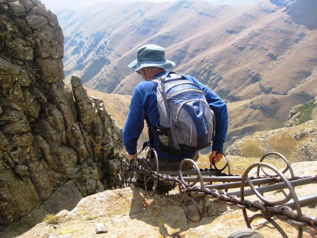
to view the bottom of the cascading waters—too far down. The excitement does not end there. Two sets of chain
ladders are positioned immediately before the summit to enable the hiker to scale the vertical walls. As a bonus,
horse rustlers apparently operate in the region and can be less than friendly to strangers encroaching on
‘their territory’. The stage is always set for a fantastic experience at the ‘Monti’.


The first set of chain ladders below the summit.


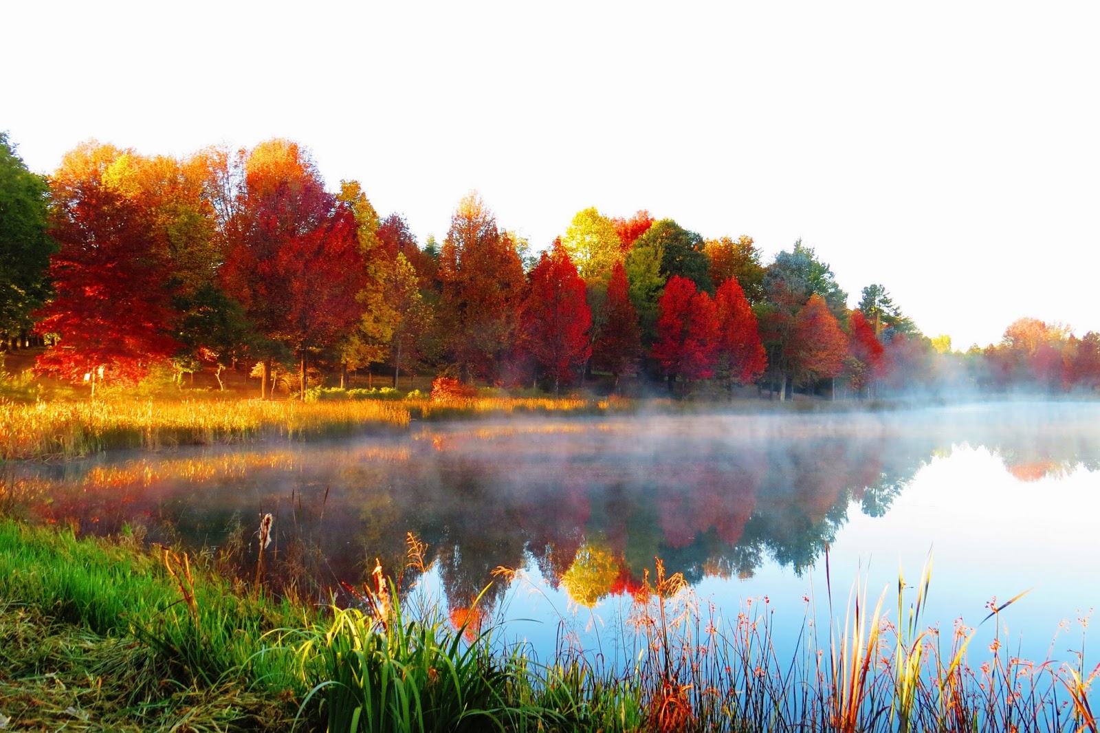
One of many scenes of the interplay of clouds and mountains.


Editor approaches boldly, one wrung at a time, the second set of chains.


The Drakensberg Mountains
do not allow motorists to ride over them at will. It usually means driving
long distances to circumvent these large basalt formations. Of course, hotels and lodges usually quote
‘as the crow flies’ mileage to prospective guests—a good tip for those wishing to visit this incredible
region. Mont-aux-Sources, more specifically, the Sentinel Hike is in the Northern Drakensberg, the High Berg.
We reserved a chalet at Witsieshoek which actually manages the trailhead. By this, we mean it charges a person
to enter the area which is literally, the end of the road. The said road ends under the massive Sentinel Peak,
situate in the Free State, on the Kwa-Zulu Natal border. Basically, Lesotho, Natal and the Free State are cozy
with each other in this area.


A window next to the chains.


We walk past the Sentinel, circle and climb behind it to reach the mountain summit.


'Gentleman' commences return down the upper-chain-ladder.


It was terrific to return and see the same staff members working at the hotel. A driver, now promoted
to waiter, Ezekiel, did not recognize us, at first. After the hike, we sat in the lounge as we prepared
to do some work. Samson, another employee joined us for a drink and we spent time swopping hiking
experiences of the Drakensberg. As we looked through some past photographs, one of Ezekiel and the writer
popped onto the screen. It was hard to tell if Ezekiel’s face went red. All we can say is he’s a fine gentleman.

We met a professional photographer, Doug Morton, in Himeville, the stop before. We were fortunate to
hear some of his experiences and see a few of his fine works. He mentioned, when he heard we were
heading north, that a storm was moving up from the Cape. A day later, when we arrived in Witsieshoek,
the clouds were heavy and looked ominous. The night before the hike, we could see no further than ten feet
in front of us. The following morning, the day of the hike, until 9:30am, visibility was about twenty feet.
It looked as if the storm was going to beat us. We pushed ahead, keeping an eye on the sky when not looking
at the path. The sun struggled for a while and then broke through the clouds. Thereafter, we received a
treat supreme as we witnessed our favorite scenes—blue sky above, thick clouds below and mountains partly
protruding through the clouds. It was a delight. The day could not have been better.


Dwarfed by the action in the sky.


Mountain art of the Drakensberg.


Bringing up the 'rear'.


It’s almost embarrassing to let you know how many pictures we took. Suffice to say, our cameras
were so heavy with pictures, we barely managed to carry them back. The highlight of the day, maybe the
trip, was our time at the chain ladders. On our previous visit, the editor got a little nervous and
decided to wait at the bottom. This time, she went up and down like a pro. In fact, many prefer to go
via a gulley or at least, one leg of the trip using the gulley route. Jen looked at those chains, knew
that it’s not good to stare and moved up like a stalwart. The thing is that the longer it takes to commit to
commencing, the less chance one has of completing the hurdle. Well done, editor. (This sweetness is
part of an ongoing strategy to gain her favor).


We've looked at clouds from both sides now...


Seeking the bottom of the 'bottomless' falls, looking into the abyss.


The only negative, and that wasn’t even an issue, is that the two massive waterfalls were almost dry.
Sad but true. They tell us if there is no snow or rain, then there is no waterfall. It seems logical
and so we did not feel too bad. When we gazed over the top of the Tugela, we thought of the poor drops of
water making the journey down that cliff. What a fall! We have a theory that water flowing over the cliff
of the Tugela Falls actually expands. In other words, for every gallon that leaves the top, a little more
than a gallon reaches the bottom. ‘Nonsense’, you might exclaim. Follow us here. Imagine it arriving at the
cliff edge and as it peers over, each droplet of water that is, catches a fright. What is the natural reaction?
It ‘wets’ itself. Hence, more water. Okay, it’s a theory but bloody scary standing there looking over.


No matter at what angle we looked down the Tugela Falls, we could not see the bottom or
much water either although we were at the source of the river of the same name. It's an incredible feeling
being 'sandwiched' between sky and clouds with surrounding mountains prominent.


The sun broke through and hit the right spot as we gazed downwards.


The following day, expecting the advent of winter, we awoke to find ideal weather—there wasn’t a cloud
in the sky. We have learned never to predict the weather—you take what it gives and work within it.
We try not be intimidated by the weather as it often changes when least expected. One has to be optimistic.


Cheers,

Jenni and Jeffrey


Final picture as we go 'over the top', on the way down.

Thursday, May 8, 2014

17.14 Sani Pass: One of the highest in Africa, up and over the Drakensberg/Maloti Mountains


The target, Sani Pass, at top right.


If you're going to be drinking, then you may as well start at the top.


He doesn't look too impressed. It's a helluva long way to hike for a coke and a 'whine'.


We have mentioned a few times that the Drakensberg/Maloti Mountains form a natural boundary
between South Africa and Lesotho, formerly Basutoland. The only way to cross into either state
through KWA-Zulu Natal by road, is over Sani Pass, one of the highest in Africa. The pub, which is the
destination of many tourists making the trip from South Africa, gets its name from its position at the
top of the pass. The high point of 9,400 feet above sea level is just over 3,000 feet in elevation gain
from the South African Border Control Office and five miles distant. Sani Pass is also known as the
‘Roof of Africa’. It sounded enticing to walk out of South Africa, climb a mountain track and arrive in
another country. We couldn’t wait to try the adventure.


Editor shows how to zig and then zag as she approaches the finish.


Looking towards South Africa, the route followed, from partly up the mountain.


Sunset view of Drakensberg/Maloti section linking South Africa and Lesotho.


The funny thing is that one crosses the border after having a passport stamped, visa checked,
then drives or walks five miles before arriving at the immigration office in Lesotho. Is this area
between the two countries ‘no man’s land’, we wondered? We thought about it a while and were tickled
by the concept but decided, we don’t really care. In a matter of five hours, four of them hiking,
one sitting in a pub in Lesotho, our passports were stamped four-times each. It is the first time
we’ve needed travel documents for a hike. It felt odd to walk out of South Africa, (tough hike actually),
and then jog back into the country. Imagine the scene. A person stops you on a jeep trail and asks,
“Where are you running?” Our reply, ‘We’re jogging to South Africa.’ Sounds impressive particularly
should you be in Kenya at the time.


We met 'Linus' on the way down. A security blanket or the national dress. Go with the latter.


Gained altitude of slightly over 3,000 feet, five miles each way. Thought of repairing the signage while
we had nothing better to do.


Most people drive up the pass to reach Lesotho. The South African regulations demand that only
4X4 vehicles be allowed to travel the treacherous road. Although we only have two legs each, we were
not questioned and were allowed to proceed under our own steam. When researching the hike, we came upon
many conflicting bits of information. Most of it is written for cars and motor bikes. Cyclists and hikers,
of which there are very few, have to rely upon data relayed by drivers. Once we had read the internet
chatter, we thought it would be extremely difficult. However, it turned about to be tough but less
difficult than many hikes.
We decided to jog down the mountain on our return, something we did for two-thirds of the way. Jogging on
loose rocks and stones is not an ideal running surface. For the record, it took us a little less than
two-and-half hours up and an hour–and-twenty down. However, the rough terrain gave our legs something
to whine about for at least the next day or so.


Another scene at the Berg as we get higher. (Note cars climbing on far right)


Not an enticing camp at the top, on the border.


A little perspective from the top. Under snow or mud it can be a little tricky, we believe.


Now for the interesting bit. Nestled at the bottom of the pass, approximately six kilometers
from the border is the Sani Pass Hotel. Almost 40 years ago, we enjoyed our honeymoon at this establishment.
It seems hard to imagine that so much time has elapsed. We have shared a bed for that amount of time.
Wow! On odd numbered nights, Jenni sleeps in the bed and the husband beds down on the floor; on even
nights, we switch. During the honeymoon, we never once contemplated hiking the 3,000 feet to another
country. Apparently, our editor found us very attractive at the time and did not want us to strain
ourselves. Fortunately, we were confined to the hotel premises. How the times are a changing.


Those giants followed us the full way up...and down. (We ended up flush with them at the summit).

Cheers,

Jenni and Jeffrey


After coming down from Sani Pass, we thought we'd step into the 'Happy Store' and
see 'what's up' in Underberg.


Some local color. We don't know about you but don't you just 'hate a show-off'?

Tuesday, May 6, 2014

17.13 Pictures without words, the Southern Drakensberg, Kenmo Lake and others.


We did say this blog is without words. It's almost accurate but for the introduction to set the scene
and captions in assisting with photograph interpretation or at least, location. We hope you enjoy these; we
certainly were thrilled to see the scenes first-hand.
We set the alarm clock for 5:30am in order to beat the sun to a lake. Sometimes we don't recognize ourselves
as our lifestyle dictates that we align ourselves differently from our earlier years.


A lake we passed on the way to Kenmo, the mist thick before daybreak, while the sun reddens
the mountain tops.


'Eagle has landed...oops, actually, Egyptian Geese arrive after a very long journey.


Soon after dawn, complete silence before the birds began to chirp and chat.


A lesson learned from the birds was to watch and listen to them embrace the morning with excitement and
we suppose, joy.


The sun hits the right spot deep into autumn with mist beginning to lift.


A view of the destination, our hike to Sani Pass extreme right; photo taken at sunset.


The other bank as the mist thickens.


A lonely duck.


The rising sun catches the trees at the end of the lake.

The following is an insight into a special day in which we experienced some of the best times ever. A full blog or two on the Mont-aux-Sources Hike, will follow next week:


Jenni approaching chain ladders on way down from Tugela Falls, Mont-aux-Sources.


She did it, I knew she could do it and she did indeed: Eliza.


A feeling of being on top of the world, Sentinel Hike.


The subject is looking at the Tugela Falls, the second highest in the world.


We see only happiness in this picture.


Cheers,

Jenni and Jeffrey